All posts by Administrador

Cork Oak Natural Park Route

Los Alcornocales Natural Park

This linear route is a perfect way to experience the essence of the Alcornocales Natural Park and to enjoy superb panoramas. You can see deer and vultures among other species and ride through verdant forests of Portuguese Oak and Cork Oak, and pass by streams where the vines climb to the top of the trees.

Commencing in the recreation zone of Picacho, we follow the road that joins Alcalá de los Gazules and Puerto Gáliz . Along a sealed road we ascend for 5 kilometres with some steep ramps, but the effort is rewarded with marvellous views of the nearby peak of Picacha. A gentle descent for ten kilometres allows us to enjoy the views south in which you can see the sea on a clear day.

Another climb takes us to Tajo Sancho where there is an important colony of vultures. We continue the route accompanied by the soft sounds of running water , it curves and bends until we arrive to the lush gallery forest of the Peguera Creek.

alt_picacho

Olive Oil Rail Trail

Lucena Zuheros

Pleasant and easy ride to discover the essence of olive oil and its relation with the culture and environment of the area. The rail trail route is really flat, the only one among all these mountains that is not hilly or mountainous. It follows and old railway line that until last century was dedictaed to the olive oil industry.

We commence in Lucena among vineyards that produce the famed Montilla-Moriles fortified wines and commence a slight climb to Cabra. We are soon surrounded by olives and in Cabra the Information Centre can give you an excellent insight into the “liquid gold” produced in the area.

The well paved rail trail continues its gradual ascent next to beautiful mountain ranges to Doña Mencía, the highest point on the route and near Zuheros, a picturesque village encrusted among the rocks and with its famed Cave of Bats. Zuheros also has a beautiful curved iron bridge that crosses the River Bailón, where you can take a lovely short.

alt_aceite1

Guadiamar Green Route

Sanlucar la MayorVado del Quema

This route enables you to enjoy a pleasant ride along the banks of the Guadiamar River, which means River of Princes in Arabic. Commencing at the Vado de Quema, the place where El Rocio pilgrims cross the river with their ox-carts. The route heads north passing lush pine forests.

The Guadiamar connects the mountains to the north of Seville with Doñana marshlands and was the unfortunate victim of the worst environmental accident in Spain when a mining industry dam filled with toxic sludge broke and flooded the entire valley with polluted waste in 1998. You can still see the level the river reached on that fateful day by th emarks on some of the trees.

En route you can take a break in the information centre in Aznalcazar and visit the Buitrago Botanic Gardens before arriving to the recreation area of Las Doblas, near Sanlucar.

alt_vado

The Water Route

From Media Fanega to Guillena

A fantastic route to get to know one of the places of natural beauty on Seville's doorstep. The water route is actually a long 68km route , but we have selected the most outstanding 30 kilometre section. From the Media Fanega Rise, a natural frontier between the Guadalquivir Valley and the Sierra Morena mountains, the beginning of the route is paved alongside the River Cala and passes two hydroelectric stations that supply Seville with electricity. Curiously, they take advantage of the cheaper price of electricity at night to pump water up to a holding pond and later, during the day it is allowed to descend and so producing more expensive electricity during the day.

The path contines between holm oak and rockrose bushes until it becomes an unpaved road.

Continue the route until you arrive at the Cantina, a place with a beautiful view where you can regain your energy before continuing. From this point, the path is easier to follow and flatter with numerous benches and lookouts with fantastic views. Finally we emerge from the forested zone to descend among cultivated fields into the town of Guillena

Altimetria Rura del agua

AUTHENTIC ANDALUCIA . Sevilla and Huelva

A diverse series of rides on rail trails and tracks through the heart of olive groves and the dehesa; green meadows of holm oak where fighting bulls and Iberian pigs graze. Our routes take you to historic white Andalucian villages and the impressive karst formations of Cerro de Hierro. En route you can visit Moorish and Temple Knight castles and the charmming city of Seville. Have a close up look at the vast Mediterranean pine forests and marshlands of Doñana National Park and its abundant birdlife. We conclude in Doñana, with a magical cycle along the beach at low tide to the mouth of the Guadalquivir river to finish in Sanlúcar de Barrameda, famed for its distinctive white sherries and great seafood.

Optional visits to castles, olive oil mill, aniseed distillery and bird sanctuary.


STAGE 1: CERRO DEL HIERRO- ALMADEN DE LA PLATA // 70 km

alt_cerrodelhierro

STAGE 2: EL RONQUILLO – GUILLENA // 35.7 km

alt_ronquillo-guillena

STAGE 3: SEVILLA – VILLAMANRRIQUE DE LA CONDESA // 43.1 km

alt_sevilla_villamanrique

STAGE 4: VILLAMANRRIQUE DE LA CONDESA – SAN LUCAR DE BARRAMENDA // 70.9 km

alt_villamanrique_sanlucar

Prices

25 -30 pax 31 – 35 pax 36 – 41 pax
From 442 € From 403 € From 382 €


Includes:

  • Accommodation with half-board (breakfast and evening meal)
  • Bus and customized trailer for transportation of bikes
  • 2 Guides and mechanical assistance
  • Civil Liability Insurance
  • Taxes

Does not include

  • Bikes (Consult our prices)
  • Food en route

Consult other options for this trip


Weekend in the Cork Oak Forest Natural Park

Picacho – Peguera – Peñón de Berrueco – Rio Hoz Garganta

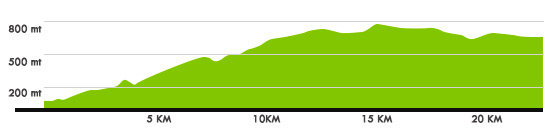
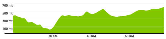
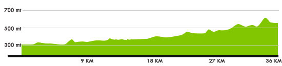
STAGE 1 – RECREATION AREA EL PICACHO – ARROYO PEGUERA. 42.6 Km. Moderate

This linear route is a perfect way to experience the essence of the Alcornoques Natural Park and to enjoy superb panoramas. You can see deer and vultures among other species and ride through verdant forests of Portuguese Oak and Cork Oak, and pass by streams where the vines climb to the top of the trees.

Commencing in the recreation zone of Picacho, we follow the road the joins Alcalá de los Gazules and Puerto Gáliz . Along a sealed road we ascend for 5 kilometres with some steep ramps, but the effort is rewarded with marvellous views of the nearby peak of Picacha. A gentle descent for ten kilometres allows us to enjoy the views south in which you can see the sea on a clear day.

Another climb takes us to Tajo Sancho where there is an important colony of vultures. We continue the route accompanied by the soft sounds of running water , it curves and bends until we arrive to the lush gallery forest of the Peguera Creek..

alt_picacho

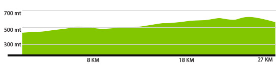
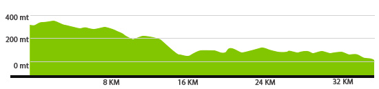
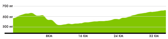
STAGE 2 – PEÑON DEL BERRUECO – RIO HOZGARGANTA. 23.7 Km. Moderate

This linear route passes through some of the most well conserved Mediterranean forest in the country. The exceptional beauty of the of the ride, with its numerous examples of cork oak, holm oak, portuguese oak and Andalusian oak, is complemented by the exciting final descent , where you can enjoy the along the banks of the Hozgarganta River which runs year round.

The route commences next to the forest track next opposite the Peñon del Berrueco. We follow this track with a moderate ascent at the beginning. The limestone peaks of the Sierra de Grazalema can be easily seen from the track and soon after the panorama switches to the the highest peaks of the Alcornocales Natural Park.

The first 11km follow the route of the GR-7, the walking track that joins Tarifa and Athens. Afterwards the track divides and we follow the right fork to ride on a long downhill that gets steeper and steeper. The ramps get even steeper which will test out both your bike and your arms!

Throughout the the ride you can enjoy the well-preserved forest of the park. The enormous Portuguese and Andalucian Oaks strive to outshine in size and shape the Cork and Holm Oak.

All in all a magnificent spectacle that ends at the road which joins Jimena de la Frontera and Puerto Gáliz near the the zone known aas Las Canillas and next to the Hozgarganta River where you can cool off in hot weather!

.

alt_berrueco

The Tunnels Rail Trail

From Coripe to Olvera

This route takes advantage of a rail route that was built in the early 20th century but was never used. It was renovated as a rail trail at the end of the 20th century.

It includes 30 tunnels, the longest almost a kilometre in length. They are equipped with lighting systems but it is a good idea to have lights in case they are not working!

The route also crosses four viaducts, the most spectacular crosses a river at the Peñon de Zaframagon, a rocky mountain that is home to a large colony of Griffon Vultures. The information centre situated in an old station enables us to get to know about the life of these amazing birds.

There are cameras which constantly film the birds so that we can learn more about their routines and raising of the chicks..

Altimetria Ruta de los tuneles


Rail Trail of the Sierra Norte

From Cazalla train station to Cerro de Hierro

The best part of this rail trail is particularly interesting because almost anybody can ride it. the route is perfectly paved for the great majority of its length. It commences near the train station of Cazalla-Constantina and continues alongside the Huéznar River to its source in San Nicolas del Puerto, which is a curious place where the cystal clear water bubbles up from the ground. San Nicolas also has a lovely fluvial beach for a refreshing swim in hot weather.

From San Nicolas the trail continues to Cerro del Hierro, an extraordinary place to explore with strange karst landforms and mining histroy and relics, it was exploited by the Scottish in the 19th and 20th centuries.

The rail trail itself is a very gradual climb and passes through Mediterranean Woods, over bridges, by holm oak meadows, through a tunnel and the lush and verdant growth around the river. A pleasure for the senses!


Altimetria Via Verde Sierra Norte